This is a lesson in site economics. I could probably fill a book with stories about my time in the Soviet Union working with a team of planners, construction executives, and resort architects trying to figure out the master concept and plan for a 30,000-acre peninsula. It is difficult to choose among the stories. There was the crab leg dinner I ate in the sauna at Brezhnev’s mansion. (Brezhnev was not there.) There was the enormous helicopter that ran on diesel fuel and its three pilots who sat and smoked just a few feet away from the fuel tank. There was the loyal worker who followed our contingent and Russian hosts literally wherever we went, continually pouring vodka into small glasses. That story I cannot seem to recall as well as the others.

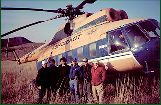
Our gang of planners, architects and developers in front of our transportation during our Russian (U.S.S.R.) trip.
This story — or lesson — is about the site we worked on: an amazing 30,000-acre peninsula jutting into the Sea of Japan and lapped by blue waters to the south and the calm ripples of a bay to the north. We were there, as our client pointed out, “to plan the Pebble Beach of Asia.” And so we eventually did.

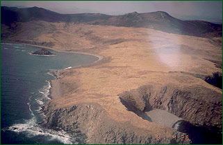
The Peninsula, as it was named, as seen from the air on one of our many flyovers. The south side of the “island” was remarkably like Pebble Beach, with dramatic cliffs, pebbly beaches and flowing land that met the sea with crashing waves and the froth of white water and aqua blues.
Our approach was to create a destination that would serve the golfing population of Japan, a mere hour’s plane ride away. This amazing land was in Asiatic Russia near the maritime submarine port of Vladivostok. The chief planner was Vernon Swaback, an acclaimed architect, visionary, and author who had worked with the legendary Frank Lloyd Wright. Swaback started his own practice in the desert of Arizona, where he has planned several large resorts and communities, each something to behold in the creativity and comfort they reflect. Swaback pointed out how we needed more than golf at what became known as The Peninsula. He noted that the concept of destination was going to require activities that would keep guests there for longer stays, especially when the weather was not conducive to golf.
As the plan unfolded, the team had sketched a fishing marina, a recreational boat marina, three resort lodges, a major spa, hunting grounds, and as many as 108 holes of golf spread over seven miles. Courses were clustered, some sharing a clubhouse and others as stand-alone 18-hole layouts with individual themes. There were as many as 20 credible ocean holes among the courses. Two in particular, I profoundly remarked, would be nearly as special as anything Seventeen-Mile Drive had to offer.
It was a breathtaking — and ambitious — plan, and everybody was enthusiastic about taking it to the next step. As the plan progressed, it became clear to us that the absence of infrastructure was perhaps an insurmountable obstacle. It had been noted that the site would require a nearby airport, a desalination plant (for drinking and irrigation water), and the construction of a new road, if not for access by guests, at least for the purposes of delivering goods from Vladivostok, some three hours away by truck. All told, the bill – even before development – might exceed $2 billion.
Eventually, the Soviet Union became the Russian Federation. The iron curtain was lifted, and what little was left of the economy took an even greater beating. Not only would there be no help from the Russians, but the uncertainty of doing expensive business in such a political and economic climate was unappealing to investors.
Through planning and site evaluation, we concluded exactly what a good planning team is supposed to conclude: whether the project is viable or not. It was a painful realization, but it may one day pay off. After all, the land is still there — and so are the plans.
And then there was the “Secret Topo”
The trip to Vladivostok, Soviet Union, involved nine Americans: a planner, two developers, two golf course management executives, a construction executive, two golf course architects, and an interpreter. Our charge was to investigate a large uninhabited peninsula, really an island, and determine the viability of turning it into a destination resort with multiple golf courses.
Before we left home, we asked the Russians to send us a copy of the topo for the land. The idea was for us to study the site and form general opinions before getting there. But no topo arrived before we left.
When we arrived in Russia, one of the first questions asked was about the topo. “Topo is coming soon,” came the reply. We believed this and spent the next 24 hours adjusting to the time change a world away.
The next day arrived, but no topo. And then the second day. The third. And a fourth. We had eaten plenty of Russian cuisine. Drank plenty of Russian “mystery juice.” And sipped plenty of Russian vodka. Each of these was a precious commodity. Topo, apparently, was even more precious. So, too, was the ability to actually visit the site. Our hosts took us to virtually every corner of Vladivostok and the surrounding countryside except the focus of our visit, the site itself.
That we were in Russia trying to design such a major project and had neither visited the site nor been given topographical maps began to disturb us. While the developers met behind closed doors to discuss financial issues, the architectural and design contingency toured buildings, fisheries, and technical schools. When we inquired when we would visit the site, we were told the weather was not right for the helicopter. When we asked about the maps, we were told they would be ready soon.
The requests for maps were beginning to get old, both for us and for the Russians. Finally, in the context of a financial discussion, one of the developers made a strong request that we all really needed to get to the site and “by the way, topo maps would be helpful.” This seemed to work, likely because developers tend to talk finances and finances tend to mean business. That evening we were informed that we would visit the site in the morning, by helicopter. The anticipation mounted. After being in the Soviet Union for almost five days, we had not even visited the site, where there was much work to be done, nor had we any idea beyond a road map what the land really looked like. In fact, a map of North Korea that I had purchased back in Phoenix actually showed the peninsula land — it was just under 1/4 inch long and, if you really tried, you could make out the way the ocean and bay formed the protrusion of land. This had been our only reference. A dot on the map which had been pointed to by pencils, pens, and fingers.
As it happened, we did take off in the morning but could not land due to windy conditions. Our helicopter was a massive beast that could hold 45 soldiers. On this day there were just nine of us and an equal number of local officials. We did manage a great flyover of the property. It was absolutely breathtaking. Still, we needed maps!
That night — the end of our fifth day in Russia — we conspired how to get maps. It was like a secret meeting of the nine Americans, plotting about who to ask next . . . and wondering why it was so damned hard to get a topo map. True, placing a phone call to the United States involved five or six Russians, and even then you might reach Ohio, perhaps northern California, or occasionally New York. The economy and infrastructure were crumbling. We could see this, yet it still seemed odd that no topo map had been presented.
That night, we cooked pasta for our hosts; we had brought it from the States complete with meat sauce. They had never had any such a delicacy and were grateful for the cultural enlightenment. It must have worked. We were told that the next morning we would drive to the site and that — they promised —”topo will be in morning for you.” Translated: Topo will be available tomorrow.
This indeed did happen. The drive itself is another story altogether. Arriving at last was a magical experience. Finally, we were at the site and not hovering in a military helicopter at 1000 feet. Our motorcade made its way across dirt trails, and for the next several hours we absorbed the site and its tremendous potential. Toward the end of the afternoon, we arrived at an old mansion that had been used for bombing practice. As we explored the ruins, we noticed a man in a trench coat unfolding a small map. Alas! Topo.

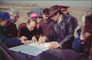
Finally.the topographical map was unveiled. Here, an anxious group of consultants (I’m the one with the scale) begins to look at the map we have been waiting days to get a look at.
We learned later that the topo was government property and, as such, was closely guarded. In fact, it was stamped CHENRENKO (SECRET). On the way back home a few days later, I had the terrifying realization that contained in my briefcase was a secret Russian document. The thought crossed my mind that I might be detained by the Russians and accused of spying. That, too, is another story.
